
Volcanism
Last fall I decided I wanted to ski as many of the Cascade volcanoes as I could during the spring. I felt in need of a project and an effort that tested me in a new way. As a cross country skier, the majority of my events have been between fifteen minutes to two hours. I wanted to explore a different side of endurance that tested myself not over minutes, but days and weeks. Specifically ,I was interested in experiencing the physical challenge and mental spaces that sustaining low intensity but high volume work over a long period of time would put me in. To add to the challenge, I decided to attempt to link all of these volcanoes by bike.
It was an audacious plan. It began with convincing my father, Dave, to schlep my gear around the pacific northwest for two weeks, while sleeping in my van with me and my stink. He had just completed a ski trip in Alaska and aggravated a knee injury he sustained while skiing with me in Chamonix this past winter. This meant he wouldn’t be able to join me on any of the volcanoes either. I am beyond grateful for his commitment despite these circumstances, as I would not have been able to do this without him. We began planning, reaching out to contacts, and gathering beta for thirteen volcanoes. My natural inclination, perhaps stemming again from my background in very standardized endurance sports such as cross country skiing, was to fixate primarily on the demands of the physical acts of skiing and cycling.
As I dove deeper into the project, I realized this was going to be an immense logistical challenge that required coordinating weather windows, ski partners, and flexible time frames to even get me to the base of a volcano in the first place. It was going to be a test in adaptation. Luckily, I had the most thorough and adept problem solver in my dad by my side. We knew we would have to make changes on the fly, and I trusted him to help me navigate the challenges I could anticipate and those I could not.


Dave making lunch at one of our many stops at TJs (top) and a solid shot of my van (bottom)
For around four months we generated routes and I accumulated the necessary gear for the adventure. With my primary motivations to test myself endurance wise by skiing volcanoes and cycling between them, we set relatively low expectations to what this adventure would actually end up looking like. I initially had planned to begin with Mt. Baker and proceed south through Washington. This was for two reasons. The first was that my A priority Cascade Volcanoes such as Glacier, Rainier, and Adams all lie in this zone. Gaining a two week long weather window was unrealistic. Starting the trip with 3-4 days of promising conditions meant I could attempt some of these bigger volcanoes and logistically give potential partners a narrower time frame to when I would make these attempts, as opposed to if I finished the trip with these volcanoes. The second was that I would be fresh, and these volcanoes required the biggest days of both skiing and cycling.


I encountered all types of weather both cycling and skiing. Both of these photos are from riding over Crater Lake Highway where it was sleeting and 20F.
We both agreed that given some prior commitments beginning in June and spring forecasts, the best window for the trip was the month of May. As April ended, the previous month of high pressure and ideal volcano conditions that the PNW had experienced did as well. We were skunked by some big storms that hit the Cascades the first ten days in May. Impatient, and with no end to the storm's in sight, I decided to flip the trip and start south at Shasta.
The Trip
On May 14th, Mike Hogan, CEO of Hagan USA, and I climbed and skied Mt. Shasta. The next day, I hopped on my bike and rode north following the Klamath River across the border to Oregon and Mt. Mcloughin. This was the start of 10 days of activity totaling 7 volcano summits, approximately 500 miles, and 66,000 ft of elevation gain.
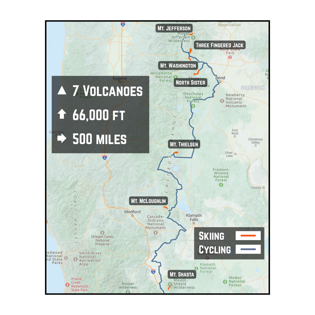
Volcanism in its final form
|
Day |
Mode |
Route |
Distance (miles) |
Elevation Gain (ft) |
Time (hours) |
|
1 |
Skiing |
Mt. Shasta |
12.78 |
7,278 |
6.5 |
|
2 |
Biking |
Mt. Shasta to Mt. Mcloughlin |
130.72 |
8,465 |
9 |
|
3 |
Skiing |
Mt. McLoughlin |
10.25 |
4,732 |
4.25 |
|
3 |
Biking |
Mt. McLoughlin to Mt. Thielsen |
87.81 |
5,230 |
6 |
|
4 |
Skiing |
Mt. Thielsen |
9.00 |
4,892 |
4.5 |
|
4 |
Biking |
Mt. Thielsen towards Three Sisters |
61.97 |
2,005 |
4 |
|
5 |
Off/Weather Delay* |
||||
|
6 |
Biking |
Continuing to Three Sisters |
94.07 |
4,616 |
6.5 |
|
7 |
Skiing |
North Sister* |
16.17 |
7,192 |
9.5 |
|
8 |
Biking |
North Sister to Three Fingered Jack |
18.19 |
2,208 |
2 |
|
9 |
Skiing |
Three Fingered Jack |
11.48 |
5,820 |
6 |
|
9 |
Skiing |
Mt. Washington |
9.24 |
4,249 |
4.25 |
|
9 |
Biking |
Mt. Washington to Mt. Jefferson |
31.19 |
1,437 |
1.7 |
|
10 |
Skiing |
Mt. Jefferson |
15.8 |
8,491 |
7 |
|
Totals |
508.67 |
66,615 |
71.2 |
||
Each day broken down. * more on day 5 and 7 later.


Following there Klamath river (top) and Mike and I on top of Shasta (bottom). It was the windiest summit I've ever been on.


Rime on Mt. Thielsen (top) and the view (and also the only view I ever got) of Mt. Mcloughlin from the campsite (bottom)
The complexity created by essentially limiting my mobility by biking, meant we had no option but to take it one day at a time. I found this quite freeing, knowing I was where ever I was on the route and that was the end of the story. We would adapt my next move of skiing, biking, or waiting to wherever I ended the day and what the weather had in store. There wasn’t any pressure to get somewhere. This let me really enjoy the moment, from cycling on some remote single track to bushwacking across the PCT on my skis, and experience the feelings of aliveness and remoteness that to me are really special.


A look inside the van after a wet day (top) and Mt. Thielsen poking through the clouds (bottom)
I owe it to my Dad in cultivating this environment, truly giving his entire self into supporting my agenda. Despite I am sure being sick of driving, wanting to sleep in his own bed, and forced to rehab his knee on the go, he was relaxed and content wherever we were at the moment, and continuously scouting and gathering beta for wherever we would be next. This created the space for me to really enjoy and immerse myself in what was doing stress free, and that is a gift I am grateful for.


Getting to bike with my dad through Bend, OR (top) and the engineer at work fixing my broken Boa (bottom)
Takeaways
Weather/visibility challenges:
Perhaps obvious to the mountaineering crowd, but it was shocking to me how much this project was dependent on weather. From the very beginning, mother nature forced me to flip the adventure in reverse. Segment routes, both biking and skiing, were determined by the weather, which impacted where I was going and what I was doing each day. We spent the downtime throughout the day pouring over forecasts, models, and talking to sources on the ground to try and gather a sense of what was happening on the volcanos. I’ll be honest in that I was naive in initially thinking that maybe this was a bit overkill. On Mcloughlin I learned it was not. Visibility went to zero as I wandered out of the treed approach and up towards the summit. At the top I experienced 40 mph plus winds and couldn’t see more than a few feet in front of me. Skiing down was monotonous as I tried to pick out landmarks one foot at a time having lost all sense of proprioception between myself and the ground. It wasn’t fun and I couldn’t imagine getting caught in a similar situation on a bigger mountain such as Rainier.


Perfect weather on Mt. Jefferson (top) and not so perfect weather on Mt. Mcloughlin (bottom). In the end I did continue up to the summit of Mcloughlin after having spent some time contemplating below treeline.
On the fifth day, the weather on Three Sisters forced me to take a break. Even in the end, my primary reason for ending the trip after Mt. Jefferson was due to weather conditions on Mt. hood and Mt. Adams that would force me to twiddle my thumbs for a few days. I think I was realistic in my estimation of how long something like this would take me physically, but underestimated the delays that weather could inflict. If you had a consistent high pressure window, as there was in May, this adventure becomes much more straightforward. However, this cannot be controlled, and the best thing to do is to set aside as much time as possible.
Communication/survival in remote environment
I was lucky enough to have a good friend join me on the Three Sisters Traverse. For those not familiar, this is a 25 mile 10k point to point traverse across North, Middle, and South Sister. I took a rest two days prior to line up our attempt with the most advantageous weather window. We nailed it. It was blue skies, and no wind; the quintessential conditions that come to mind when I picture Oregon spring skiing. Unfortunately, my buddy took a fall coming down North Sister and we were forced to abandon our attempt at the traverse. Thankfully we were able to walk out, had plenty of daylight, and were able to communicate with my Dad to make critical decisions. In reflection, it caused me to think about how I would act in situations when these factors are not in my favor. Despite temperatures hovering around 40 F and full sun, my friend quickly moved towards hypothermia due to shock. Even with three down jackets, snow pants, and hand warmers, it still took him a good hour to warm up. If the conditions were not as ideal as they were, this exposure would have been a significant challenge. Moreover, we barely overcame this with him being fully mobile and having packed layers that I usually don’t bring on “sunny” days. So, I take two lessons away from this event. The first is I feel much more inclined to truly maximize conditions when attempting bigger and more remote objectives than I did before the trip. It’s safer and more fun. The second is to pack layers as not just resources for the current weather, but to mitigate hypothermia in the case of a rescue.


Waiting for a weather window for Three Sisters meant that when things went wrong we could walk out. Looking from North Sister towards Middle and South Sister (top) and the view of all Three Sisters on the approach in (bottom)
Compounding fatigue within a technically demanding sport
Overall, I was impressed with how my body reacted to the effort. I never felt overly taxed, and my pace of travel seemed quite sustainable. I was tired, and there were stressful moments when things weren't going to plan. Yet, I went into the adventure knowing that these moments would come, and that in some ways these moments were what I was looking for as they would push me to adapt. So when they did inevitably come, and my boa broke, or it snowed over cascade pass, or fog rolled in while scrambling on top of Mt Thielsen, I was ready. I wasn’t prepared to necessarily have a solution to the problem right then, but I knew that these challenges were all part of the process and that I would be able to figure them out.


Red dirt on the way to Three Fingered Jack (top) and the summit of Three fingered Jack (bottom)
I’ve gained a greater appreciation for the technicality of big mountaineering expeditions. This is one of the first times I’ve noticed my reaction rate and general computational ability affected by physical exertion. In some of the exposed and technical climbing sections later into the trip, I had to really focus on keeping myself engaged and making the movements that normally I wouldn’t need to think about. I was experiencing this mental deterioration while still getting around 7 hours of sleep every night. Killian Jornet’s ability to have performed extremely technical ascents of 4000 meter peaks 82 times in a row on an average of 5 hours of sleep during his Alpine connections project is truly remarkable, and speaks volumes to his cognitive durability and skill.


(top) On Mt. Washington during nA 10 hour day skiing both Three Fingered Jack (in background) and Mt. Washington, and then cycling to Mt Jefferson (behind Three Fingered Jack). A technical scramble up to the top of Mt. Thielsen (bottom).


On the return from Mt. Washington (top) and the summit of Mt. Jefferson (bottom)
If I fuel properly as I did during this trip, consuming on average 90g of Carb an hour, and I keep my purpose and motivations in perspective, I know I can do much more work than I would have thought prior to this experience. It makes me excited for similar adventures and longer endurance racing efforts in the future. Not to mention, I didn’t even touch Washington during this trip so I will be returning to the Pacific NW for more volcanoes at some point. I am beyond grateful for everyone that supported me during this trip, from those watching my tracker, to Mike at Hagan, and most importantly my Father who made this opportunity to expand my physical and mental experience a reality. This was one of the most fun projects I’ve ever set out to do and I can’t wait for the next one.

My favorite photo and one of the top moments from the trip. Looking back down the line of Volcanoes from the top of Mt. Jefferson.
2 Responses

Leave a comment
Comments will be approved before showing up.

Jeff Goodman
July 07, 2025
Truly amazing Simon. Very impressive‼️
It was fun for me to read your well written and engaging recap of your feat.
You are also so fortunate to share this grand adventure with your father who, like you, has a knack for conquering what most other mortals would find daunting and overwhelming.
…..which is a roundabout way of saying that the 🍎 does not fall far from the 🌳